NISAR: A newly released radar image from the US–India NISAR Earth-observing satellite has provided a strikingly detailed look at the Mississippi River Delta in southeastern Louisiana. Captured using advanced radar technology, the image highlights the region’s dense urban centers, vast wetlands, forests, and agricultural land, offering scientists a clearer picture of one of the most environmentally complex areas in the United States, according to NASA.
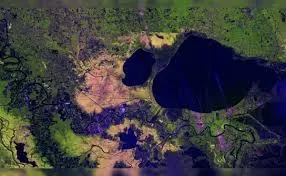
Image Captured by Advanced Radar Technology
The image was recorded on November 29, 2025, using NISAR’s L-band synthetic aperture radar system. Unlike traditional optical imagery, radar can collect data regardless of cloud cover or lighting conditions. This capability allows researchers to observe surface features based on how radar signals interact with different land and water surfaces, producing a detailed and reliable representation of the landscape.
Urban Areas and Major Landmarks in Focus
Within the image, major population centers and landmarks stand out with clarity. New Orleans is visible alongside the winding course of the Mississippi River and the expanse of Lake Pontchartrain. One of the most prominent features is the Lake Pontchartrain Causeway, identifiable slightly to the right of the image’s center. The twin spans extend nearly 24 miles, making them the longest continuous bridge over water anywhere in the world.
River Path and Surrounding Forests
The Mississippi River traces a diagonal path across the image, flowing from Baton Rouge in the upper left toward New Orleans in the lower right. On the western side of the river, bright green areas signal dense and healthy forests. These regions reflect radar signals in complex ways due to thick vegetation, allowing scientists to distinguish forested land from other surface types with precision.
Wetlands Show Signs of Ecological Stress
In contrast to the vibrant forest regions, the Maurepas Swamp west of Lake Pontchartrain and Lake Maurepas displays a patchwork of yellow and magenta shades. These tones suggest changes in the wetland forest structure, including thinning tree coverage. Variations in radar reflection patterns help researchers identify areas where ecosystems may be under stress or undergoing gradual transformation.
Agricultural Patterns Along the River
Farmland on both sides of the Mississippi appears in a variety of shapes and color intensities. Darker patches typically indicate fields that are not currently cultivated, while brighter magenta areas point to the presence of taller vegetation, such as active crops. These distinctions make radar imagery a valuable tool for monitoring agricultural activity across large regions.
Technical Capabilities of NISAR’s Instruments
The image also demonstrates the scientific potential of NISAR’s radar systems. The L-band radar operates with a wavelength of approximately 24 centimeters, enabling signals to pass through forest canopies and provide measurements of soil moisture and subtle land movement. This level of detail is essential for studying natural hazards such as earthquakes, landslides, and volcanic activity.
Complementary S-Band Radar for Vegetation Monitoring
In addition to the L-band system, NISAR carries an S-band radar developed by India’s Space Applications Centre. With a shorter wavelength of about 10 centimeters, this instrument is particularly sensitive to smaller vegetation. It is well suited for tracking changes in crops, grasslands, and other low-lying plant cover, complementing the broader measurements provided by the L-band radar.
Supporting Global Earth Science and Disaster Response
Launched in July 2025, NISAR was designed to collect frequent, high-resolution data across the globe. Its ability to revisit the same locations quickly allows scientists to compare conditions before and after major events. This rapid coverage is expected to play a key role in disaster response, environmental monitoring, and long-term studies of Earth’s surface, ice, and ecosystems.
Contact to : xlf550402@gmail.com
Copyright © boyuanhulian 2020 - 2023. All Right Reserved.