Earthquake in Kolkata: A magnitude 5.7 earthquake near Dhaka, Bangladesh, on Friday caused noticeable tremors across Kolkata and several parts of Northeast India, according to the US Geological Survey (USGS). The quake led people in multiple cities to step out of homes and offices as a safety measure.
Kolkata Earthquake: Where the quake originated
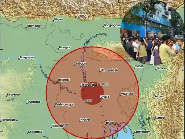
USGS said the epicentre was 13 km south-southwest of Narsingdi in Bangladesh. The quake struck at 10:08 am at a depth of 10 km, making it a shallow event. Shallow quakes tend to produce stronger shaking as seismic waves travel a shorter distance to the surface.
Why Kolkata experienced short but strong tremors?
Eastern India felt short but strong tremors because the earthquake that struck Bangladesh was shallow and close to the region’s northern border. The US Geological Survey said the quake measured 5.7 and occurred at a depth of 10 km near Narsingdi. Shallow quakes send stronger shaking to nearby areas as the seismic waves travel a shorter distance to the surface. Cities such as Kolkata, Guwahati, Agartala and Shillong are close enough to Bangladesh’s active fault zones to feel the impact even when the epicentre lies outside India.
Earthquake in Kolkata: Cities that felt the tremors
In Kolkata, residents felt brief tremors around 10:10 am, with many describing the shaking as lasting only a few seconds. People in several neighbourhoods and nearby districts moved outdoors as a precaution. Videos showing ceiling lights moving and people gathering on streets spread quickly on social media.
Early reports said people in Guwahati, Agartala and Shillong also felt mild tremors around the same time. Authorities said there were no immediate reports of injuries or damage from any of the affected cities.
What caused the tremors in Kolkata: Recent seismic activity in Bangladesh
Bangladesh experienced a magnitude 3.4 earthquake in October, according to the National Centre for Seismology (NCS). The Daily Star, citing USGS data, noted that globally an earthquake occurs roughly every 30 seconds, though most are too weak to be felt.
West Bengal:
According to hazard-mapping, parts of the Indo-Gangetic plain, including northern West Bengal, are classified under Zone IV.
These areas are vulnerable because of their proximity to active fault lines and their geological structure.
Kolkata Earthquake: Where the quake originated
USGS said the epicentre was 13 km south-southwest of Narsingdi in Bangladesh. The quake struck at 10:08 am at a depth of 10 km, making it a shallow event. Shallow quakes tend to produce stronger shaking as seismic waves travel a shorter distance to the surface.Why Kolkata experienced short but strong tremors?
Eastern India felt short but strong tremors because the earthquake that struck Bangladesh was shallow and close to the region’s northern border. The US Geological Survey said the quake measured 5.7 and occurred at a depth of 10 km near Narsingdi. Shallow quakes send stronger shaking to nearby areas as the seismic waves travel a shorter distance to the surface. Cities such as Kolkata, Guwahati, Agartala and Shillong are close enough to Bangladesh’s active fault zones to feel the impact even when the epicentre lies outside India.Earthquake in Kolkata: Cities that felt the tremors
In Kolkata, residents felt brief tremors around 10:10 am, with many describing the shaking as lasting only a few seconds. People in several neighbourhoods and nearby districts moved outdoors as a precaution. Videos showing ceiling lights moving and people gathering on streets spread quickly on social media.Early reports said people in Guwahati, Agartala and Shillong also felt mild tremors around the same time. Authorities said there were no immediate reports of injuries or damage from any of the affected cities.
What caused the tremors in Kolkata: Recent seismic activity in Bangladesh
Bangladesh experienced a magnitude 3.4 earthquake in October, according to the National Centre for Seismology (NCS). The Daily Star, citing USGS data, noted that globally an earthquake occurs roughly every 30 seconds, though most are too weak to be felt.Why is the region earthquake-prone?
Bangladesh sits at the junction of the Indian, Eurasian and Burma tectonic plates. The Indian plate moves northeast at about 6 cm per year, while the Eurasian plate moves north at about 2 cm annually. Several major faults—the Bogura, Tripura, Dauki and Assam faults, along with the Shillong Plateau—cut through the region, placing it within 13 identified earthquake-prone zones.What are the high-risk earthquake regions in East India
High-risk seismic regions in West Bengal and Northeast / East IndiaWest Bengal:
- According to seismic zoning maps by the Bureau of Indian Standards (BIS), parts of West Bengal fall into Zone IV (High Damage Risk) and Zone V (Very High Damage Risk).
- Specifically, the eastern districts of Jalpaiguri and Cooch Behar are in Zone V.
- Darjeeling, North & South Dinajpur, Malda, and 24-Parganas (North & South) are in Zone IV.
- Districts such as Kolkata, Murshidabad, Birbhum, Bardhaman, Hooghly, Howrah, Nadia, Bankura, Midnapore lie in Zone III (moderate risk).
- The entire Northeast (states like Assam, Arunachal Pradesh, Meghalaya, Nagaland, Manipur, Tripura, Mizoram) is classified in Seismic Zone V, which is the highest-risk zone in India.
- In Assam in particular, almost the entire state lies in Zone V.
- One of the major tectonic features is the Shillong Plateau and the Dauki fault (along its southern boundary), which contributes significantly to seismic risk in parts of northeastern India.
According to hazard-mapping, parts of the Indo-Gangetic plain, including northern West Bengal, are classified under Zone IV.
These areas are vulnerable because of their proximity to active fault lines and their geological structure.